Arlington Center has presented a major problem for the Minuteman Commuter Bikeway (rail trail) since its opening. For people who are not familiar with the situation in Arlington Center, the rail line passed diagonally through the middle of town, crossing the two largest streets in Arlington within a couple hundred feet of their intersection. The connecting segment of the bikeway was not built. The project represents an attempt to remedy that situation.
Review
I have discussed Arlington Center before, in blog posts and with a video, and in case you wish to review my comments, here are links to them:
My comments as of January 2012 — my comments on the project as it was being described at that time.
Arlington Center Westbound: Avoiding the Right Hook — describes a safe and convenient route through Arlington Center westbound for a cyclist operating as a driver in mixed traffic, with a video — which also shows cyclists who have unfortunate misconceptions about how to be safe. Not mentioned is that a similar route is possible eastbound, using the street adjacent to the rail trail to enter Mystic Street.
Further Suggestions for Arlington Center (as of November, 2013) — this gives my proposal for a route which I think would be most satisfactory for casual and young cyclists.
More recently, I attended a public meeting on March 23, 2016 at Arlington Town Hall. The main presenter at this meeting was Nathaniel Curtis, who works for the consulting firm for the project, Howard Stein Hudson. Dan Fielding and Chris Lahey from the Massachusetts Department of Transportation were also present, but did not speak.
The drawing below, from a 2013 presentation, shows the the design proposal at that time. The rail line followed the white, interrupted swath from lower right to upper middle, and beyond. The short stretch of blue at the lower right is the start of the eastern segment of the bikeway, ending at a small street, Swan Place. Massachusetts Avenue is the east-west street. Mystic Street heads south at the lower left and Pleasant Street heads north at the upper left. The start of the western segment of the bikeway is the wide green strip to its left.
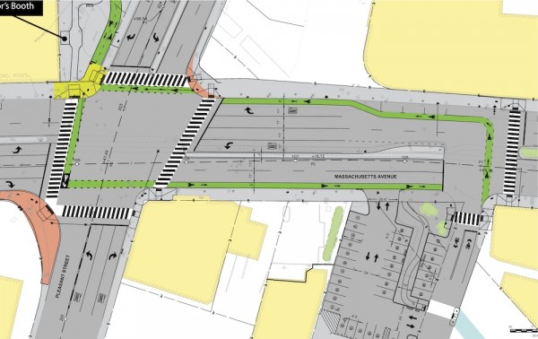
Arlington Proposal as of 2013
Changes — the main stem
I’ll first discuss the main stem of the project, Massachusetts Avenue between Mystic Street/Pleasant Street and Swan Place.
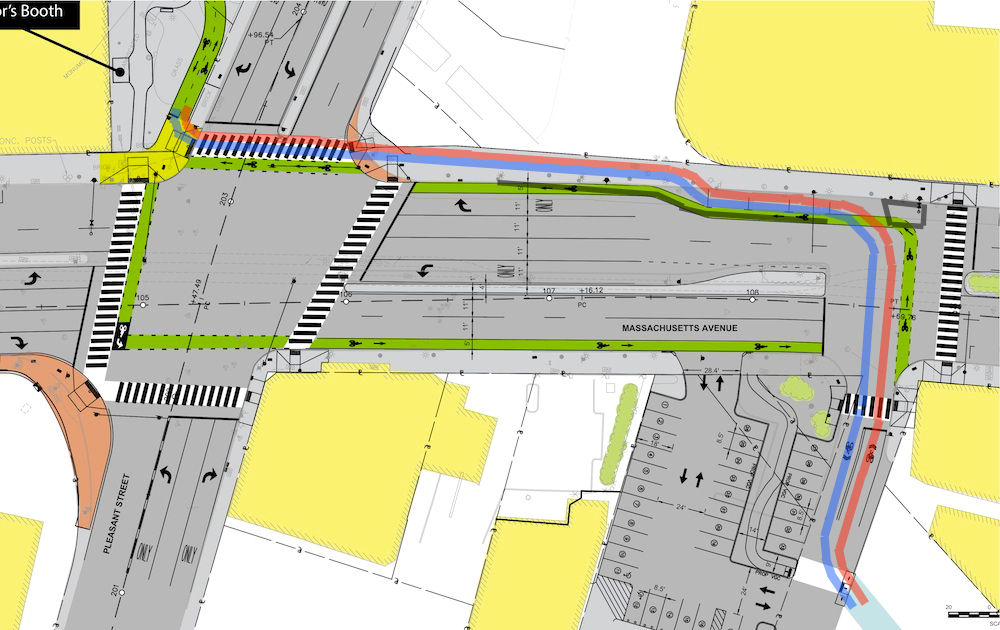
The proposal has changed somewhat since 2013. Some of the more troublesome features have been modified. You may compare the newer image below (from the town of Arlington Web page about the project) with the older one above.
- The impractical sharp turn in the bikeway (middle right, above) has been made less sharp.
- At the lower right where bicyclists enter from the street, the green bike lane now proceeds from the street rather than from the sidewalk.
- At the upper left, the bikeway continues across the intersection rather than jogging to the right.
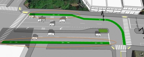
Drawing showing new bikeway alignment
Other problems remain.
- Though parking stalls are not shown in the newer drawing, they still exist near the top right where the bike lane is spaced away from the curb. The bikeway runs next to the parking spaces, largely in the door zone. Bicyclists crossing Massachusetts Avenue will be outside the field of view of motorists’ rear view mirrors until rather late, and potentially also hidden by vehicles waiting for the traffic light ahead.
- Right-hook conflicts remain at three points already already mentioned, one at the upper left and two at the lower right in the drawing.
- The eastbound bikeway (at the bottom of the picture above) crosses one or two commercial driveways — it isn’t clear whether there are two — with additional conflicts.
At the meeting, Mr. Curtis indicated that risks to cyclists will be reduced by the elimination of the six parking spaces on the south side of Massachusetts Avenue. That is likely so, by improving sight lines for motorists using driveways, though conflicts still exist. The south-side bikeway is the straight one in the image below.
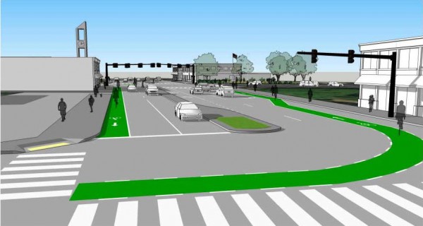
Looking west across Swan Place
The driveway barely visible at the near side of the building at the left in the image serves traffic exiting a drive-up ATM at the Cambridge Savings Bank. The Google Street View below, from August, 2011, shows this driveway as seen from Massachusetts Avenue. The blue sign at the left, reads “EXIT ONLY – Drive-Up ATM Entrance On Pleasant Street”, and there is a a one-way arrow on the pavement only in the ATM lane. There is no arrow in the adjacent part of the driveway which serves the parking lot in front of a Veterans of Foreign Wars post (the gray building in the background). It is unclear to me whether vehicles entering that parking lot also must enter from Pleasant Street.
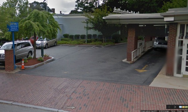
Cambridge Savings Bank and VFW Post driveway, August, 2011
In September, 2014, on the other hand, there was an arrow painted so as to indicate more clearly that this is only an exit driveway.
Cambridge Savings Bank and VFW driveway, August, 2014
Whether vehicles are effectively prevented from entering this driveway is of concern, because entering vehicles pose a risk of right-hook collisions with bicyclists in the bike lane. At the March 23, 2016 meeting, Mr. Curtis described only exiting traffic.
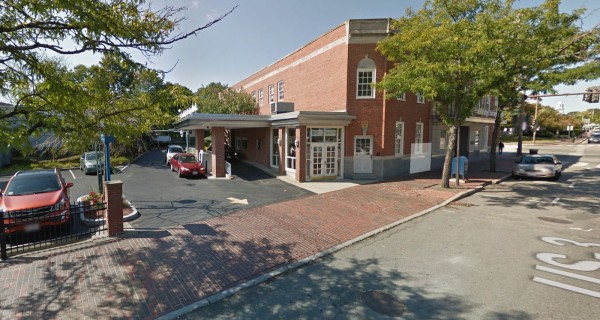
A second driveway serves both entering and exiting traffic for the Kickstand Café and Anton’s Cleaners; apparently also the VFW post.
Driveway to Kickstand Café and Anton’s Cleaners
The curb and grading plan on page 20 of the project plans shows the driveway unchanged, but the traffic signs and pavement markings plan on page 33 (as in the image below) shows a sign (SOUTH 3 EAST 2A) planted squarely in the middle of this driveway, and the drawings on the main Arlington page about the project (included above) do not show this driveway at all. Is it to be eliminated? If so, that eliminates crossing and turning conflicts at the driveway, but only by moving them to Swan Place, where the parking lot has another entrance. Motor traffic on Swan Place, used by bikeway traffic, also is increased, and removal of the driveway probably has a negative effect on the businesses served by the parking lot.
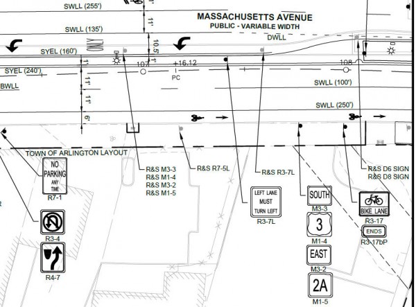
Part of page 33 of the plans showing sign planted in driveway
Next, let’s move east, to Swan Place, where the eastern segment of the bikeway ends. MassDOT and the consultant propose to install a pedestrian hybrid beacon (also called a HAWK — High-intensity Activated crossWalK — beacon) facing Massachusetts Avenue. This combines some of the features of flashing lights used at a railway crossing with those of a conventional traffic light. The beacon’s sequence, with lights that blink yellow, then go to solid yellow and red, then blink again, is unusual and can confuse drivers who are unfamiliar with it. I have commented on the very similar installation at 41st and Burnside in Portland, Oregon — useful as background information.
There are to be a stop sign and bicycle signal head (conventional traffic signal with a bicycle symbol in the signal face) facing Swan Place. The beacon is to be actuated by video detection of bicycles and by pedestrian pushbuttons.
In this connection, meeting attendee Scott Smith has pointed out an inconsistency in the plans: Sheet 34 of the 100% plans shows a Bicycle Use Ped Signal sign, while the equipment list on sheet 26 includes video detection and a bicycle signal.
Commenting at the meeting, I suggested LeddarTech LED ranging detection, which is more reliable than video detection. I got no response to this suggestion.
I understand that an ordinary traffic signal was proposed earlier for this intersection. One possible reason to use a pedestrian hybrid beacon here that it might reduce delay for traffic on Massachusetts Avenue. That is especially so near the end of the phase when pedestrians are crossing. If they have finished crossing, the pedestrian hybrid beacon allows drivers to start up, by going into flash mode. But then, so can a ranging system, by sensing when the pedestrians have finished crossing.
A pedestrian hybrid beacon is meant to be used at mid-block crosswalks. Section 4F of the Manual of Uniform Traffic Control Devices, the U.S. national reference on traffic signs, signals and markings, strongly discourages using a pedestrian hybrid beacon at an intersection with a street controlled by a STOP or YIELD sign:
The pedestrian hybrid beacon should be installed at least 100 feet from side streets or driveways that are controlled by STOP or YIELD signs…
The “should” is not an absolute prohibition — that would be a “shall” — but it is strong. The problem is this: if traffic is approaching the stop sign, it, unlike a traffic signal, doesn’t indicate when that traffic can cross safely: that is, if traffic is waiting in that street, the beacon could change and traffic could start up at any time, and the stop sign doesn’t say when it will. It is really only safe to enter at the stop sign when no traffic is approaching or waiting in the cross street.
A meeting attendee, Joe Barr from the Cambridge Traffic and Parking Department, made the point that FHWA specifically prohibits a HAWK beacon in connection with a bicycle signal, as proposed here. That is in an FHWA interim approval, and it is a “shall”.
Pedestrian Hybrid Beacons: Bicycle signal faces shall not be used in any manner with respect to the design and operation of a pedestrian hybrid beacon.
I’m not quite sure what is the rationale for this prohibition. It may result from caution in connection with an interim approval. At a crosswalk of a shared-use path, a bicycle signal could allow bicyclists, who are faster than pedestrians, to enter later. One problem might be that the bicycle signal could confuse or entice pedestrians into entering too late, though the same problem can occur with any traffic light.
But this is an intersection of a street with a street, and so there is another problem: there is no conventional signal face intended for motorists. The proposed installation asks drivers entering from Swan Place to second-guess or to take guidance from signals which aren’t intended for motorists — the bicycle or pedestrian signals. Also, the beacon, unlike a conventional traffic signal, cannot have separate right- or left-turn phases, and so it does not protect against motorists’ turning across the path of bicyclists proceeding eastbound on Massachusetts Avenue.
All of these complications suggest to me that a conventional traffic signal installation, or a conventional traffic signal facing Swan place, might be better. This would not be prohibited in connection with a pedestrian hybrid beacon on Massachusetts Avenue.
Uncle Sam Park
I’ve already discussed issues with the westbound bikeway segment leading to the northeast corner of Massachusetts Avenue and Mystic Street. Now let’s have a look at Uncle Sam Park, on the northwest corner of Massachusetts Avenue and Mystic Street.
The proposed terminus is clearly better than the present terminus on Mystic Street in mid-block at a sidewalk — yet there are some serious questions remaining.
The curve in the path at the top of the image below (from page 10 of the plans) does not meet AASHTO (American Association of State Highway and Transportation Officials) guidelines. The curve radius is much too small.
When path traffic is heavy, bicycle and pedestrian traffic traveling in multiple directions will mix at the northwest corner of Mystic Street and Massachusetts Avenue in what I expect to be a free-for-all. An abrupt narrowing of the path just before the intersection is shown in the plans, apparently to preserve an existing tree (lower middle of the image below, from page 10 of the plans). Cyclists and pedestrians can be expected to trample the grass here, or if they go around on the narrow paved strip, they will be changing direction abruptly, increasing the likelihood of confusion and collisions. This is especially a problem, as westbound cyclists and pedestrians will be entering from the left of eastbound ones. The westbound cyclists cannot be expected to stop, and some will be in a hurry to cross before the light changes. Eastbound cyclists will not stop or slow if the traffic signal favors them.
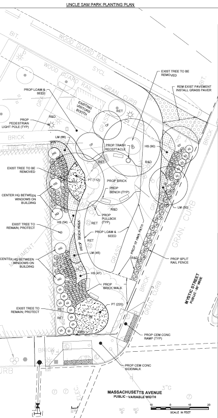
Uncle Sam Park planting plan
There is also a visibility issue between cyclists and motorists. The motorists will be coming from behind cyclists, on the left. This problem is exacerbated for cyclists who avoid riding on the grass. Traffic-signal timing here is intended to prevent conflicts, but opportunism and mistakes are likely.
Cyclists are directed to enter the intersection in lightly-dashed bike lanes ahead of boldly-striped crosswalks. Page 23 of the plans shows curb ramps placed in a compromise position, partway across the striped bike lane and partway across the crosswalk (see image below). Cyclists will generally prefer diverting into the crosswalk rather than hopping up or down a curb.
Crosswalks at Massachusetts Avenue and Mystic Street
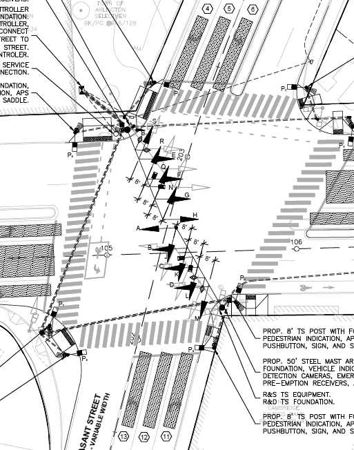
Two-Stage Turn Queuing Box
The two-stage turn queuing box near the southwest corner of Massachusetts Avenue and Pleasant Street proposed for eastbound cyclists is still in experimental status with the U. S. Federal Highway Administration (FHWA). It is supposed to be used only if a study is conducted in connection with the installation. The purpose of the rule requiring experimentation is to evaluate the effectiveness of a new traffic marking, sign or signal, and what design features are important.
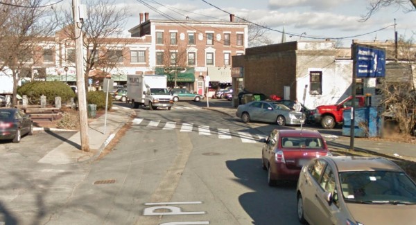
Intersection of Massachusetts Avenue with Pleasant Street (foreground) and Mystic Street (background). Two-stage turn queuing box at middle left.
I am a member of the Bicycle Technical Committee of the National Committee on Uniform Traffic Control Devices, which developed the two-stage turn queuing box proposal currently in process with the FHWA. In fact, I am one of two people who drafted that proposal. I make that point because I want to stress that I am not opposed to two-stage turn queuing boxes, though the opinions here are my own. I think that two-stage turn queuing boxes have appropriate uses. There are, however issues of design and of suitability at this location. Four issues came up at the meeting:
- Is the box large enough to accommodate the volume of bicycle traffic, and will individual cyclists on longer bicycles (longtail cargo bikes, tandems, bicycles pulling trailers, etc.) be able to make the sharp turn required by the box?
- Is this a safe way to accommodate cyclist left turns in this intersection with a motor traffic volume of 47,000 vehicles per day?
- Does this installation achieve optimum travel time — that is, low delay?
- Will cyclists using the rail trail, and particularly, casual cyclists and children, feel confident in making their left turns in this way — and so, will this installation in fact solve the problem of cyclists’ riding on sidewalks?
Some of those questions can be answered through analysis of traffic-signal timing; others, only through experimentation. Some may already have been answered through experimentation at other locations, and could point the way to whether an experiment here would be approved. I would submit in any case that this is one of the most challenging locations for a two-way turn queuing box that I have encountered.
Traffic-signal timing
Traffic-signal timing is more or less the elephant in the room with this project. There are many signals in a short a distance along Massachusetts Avenue, and a new one is proposed. There are many different movements — through, left, right, bicycle, pedestrian — accommodated in separate signal phases. These factors result in short times for green lights and walk signals.
Data pages 24 and 26 of the plans, and time-space diagrams on pages 30 and 31, indicate how long the waits will be for through travel on Massachusetts Avenue and Mystic Street/Pleasant Street. The diagonal swaths in the diagrams on these pages 30 and 31 show the windows during which drivers can pass through the entire stretch without having to stop for a red light, when traveling at 30 miles per hour on Massachusetts Avenue, or 25 miles per hour on Mystic Street. Drivers who miss these windows will have to wait through as much of the rest of the 110- or 120-second signal cycle as remains until the window opens again.
The example below is the most favorable one for Massachusetts Avenue. Motorists traveling at 30 miles an hour have a 30-second window in one direction, 38 seconds in the other, out of the 120-second cycle. Other diagrams on pages 30 and 31 show shorter windows. One is only 7 seconds long.
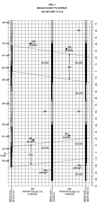
Time-space diagram
On two-way streets, it is not possible to sequence closely-spaced traffic signals for longer windows or for continuous travel. If the signals favor one direction, they will cause more delay in the other direction. The higher the travel speed and the longer the signal cycle, however, the more green time. Many pedestrian and bicycling advocates promote lower speed limits and shorter signal cycles, which run contrary to the goal of more green time.
Page 26 indicates that bicyclists will get a 24-second green at Swan Place but pedestrians get only a 10 second walk signal before it goes to a flashing don’t walk. That is appropriate, as pedestrians are slower.
Of note, the plans include no time-space diagrams for motorists turning, or for bicyclists, or for pedestrians. An important issue for me is how long it will take bicyclists to get through the entire installation. Clearly, they are going to encounter two traffic signals, whether traveling east or west. Delay — and particularly, delay when there doesn’t appear to be conflicting traffic — strongly affects the willingness of many bicyclists to obey traffic signals. The data to run an analysis exists in the plans, but I’m under pressure to complete this report, and so an analysis will have to wait for later.
The timings work only as long as traffic is flowing smoothly. They fail when traffic is congested. I am not aware of any level-of-service analysis which would show how the installation would perform under congested conditions. Mr. Curtis spoke about adjusting the signal timing, but he did not mention a level-of-service study.
It can be said though that bicyclists following the designated routes and using bike lanes will not face congestion as motorists do — unless motor traffic congestion is so bad that it backs up into the intersections.
Discussion following the presentation
Much of the discussion following the presentation at the March 23, 2016 meeting was about construction staging issues and their effect on local businesses. At times, travel lanes on Massachusetts Avenue and Mystic Street will be blocked for reconstruction of the median. Construction crews will need space for their equipment, and particularly for the work on Uncle Sam Park, however, this would appear to require only a few parking spaces in the municipal parking lot adjacent to the Rail Trail west of Mystic Street.
One citizen was unhappy with the bisecting of Uncle Sam Park by the Rail Trail. Another asked whether there would be a direct connection from the Rail Trail to the sidewalk (such as is now the only connection at the end of the Rail Trail); Mr. Curtis was uncertain about this, but as already mentioned, the plan is for “grass pavers”.
Another issue is the use of the sidewalk on Swan Place by an auto body shop for parking, and dumpsters which occupy part of the width of the sidewalk, as in the Google Street View below.This picture also illustrates the right-hook risk with the white truck entering Swan Place from Massachusetts Avenue.
Looking up Swan Place toward Massachusetts Avenue
Conclusions
Mr. Curtis indicated that there was no room for change in the project: it is going to be built as shown in the presentation, and that it had been “vetted”. Yet four features of the project — the stop sign and the bicycle signal in connection with a pedestrian hybrid beacon, the two-way turn queuing box, and the sharp turns in the bikeway at Uncle Sam Park — do not conform to national design standards. These issues, the inconsistencies in the plans and the number of other questions and safety issues which still remain, lead me to ask to what degree the project has actually been vetted, and by whom.
Mr. Curtis also repeatedly referred to the two-stage turn queuing box as a “bike box”. That is not the correct name. A bike box is a different type of installation.
All in all, the impression I get is that MassDOT and Howard Stein Hudson are treading in unfamiliar territory and have pulled innovative but questionable designs out of a hat, whether they meet standards or fit the context — these designs must be good because they are new, right?
(Projects in Massachusetts get away with violation of the national design standards because of a strong sovereign immunity law, which limits the awards in lawsuits over design issues. However, violation of standards can affect release of Federal funding.)
The name of the project, Arlington Center Safe Travel Project, makes an assumption about safety which I find questionable, and directs attention away from concerns about the actual safety and practicality of the designs proposed.
All in all, I still strongly favor the proposal I made in my earlier comments, Further Suggestions for Arlington Center. My proposal much simpler, it removes fewer parking spaces, it avoids door-zone issues and the two-way turn queuing box in the middle of the busy intersection. It offers a connection which is consistent with what casual cyclists, parents and children expect and find elsewhere on the Minuteman.
The diagram from my proposal is repeated here, but for details, please read the proposal in full. I’m open to suggestions for improvements.
My proposed route for a bikeway through Arlington Center
