[Note: this post has been updated thanks to Charlie Denison’s correct identification of the direction from which the bicyclist approached the intersection.]
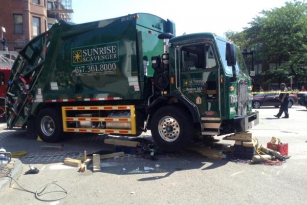
This post follows from my previous post about the right-hook collision of a garbage truck with a bicyclist at Columbus Avenue and Massachusetts Avenue in Boston. The image below is from a Boston Globe article which is behind a paywall, but in case you don’t subscribe, you may also be able to access the Globe through your local public library.
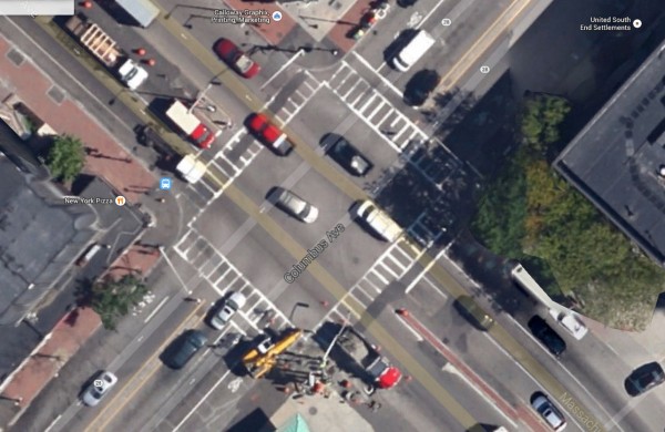
The undated Google overhead view of the intersection shows shared-lane markings, but it is older: note different crosswalk markings and that that construction work is underway.
Here’s a link to the overhead view, which will eventually be updated.
There are more recent Street Views, and they offer some teachable moments.
Let’s look at the four corners of the intersection. First, let’s look at the corner of the intersection where the crash occurred.
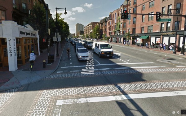
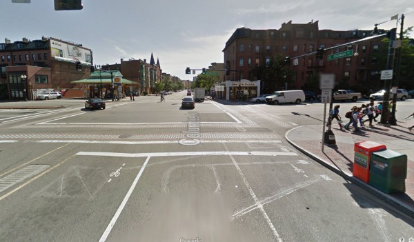
We look first to the northwest into Massachusetts Avenue, into the direction from which the bicyclist came.
The bike lane is the extension of a parking lane, placed to the right of a lane from which much of the traffic turns right, and with a “wait here” marking — only there is no actuator loop (metal detector). A bicyclist is approaching in right hook position and another bicyclist is headed away from the intersection on the sidewalk, past doors which could disgorge unwary pedestrians. There is another “wait here” marking in the left-turn lane (near the right side of the image): the only such marking in the entire intersection which is centered inside a bicycle-sensitive actuator loop where it belongs. Here’s a link to the same view, in case you would like to look around.
In the latest version of Google Maps, you may also click on the clock icon in the panel at the upper left to look at earlier Street Views. Here’s the view from July , 2011, the most recent one before the installation of the bike lane. There is no bicycle-sensitive actuator loop in the left-turn lane. This image may also reveal why none was none installed in the bike lane: the lead wires for all the others fan out from just where it would be. Installing it woudl require reinstalling all the other loops.
Here’s the link to Google for that image in case you would like to look around.
Now we go 90 degrees clockwise to the next corner. Here is the August 2013 Google Street View from Columbus Avenue.
Near the right curb are a “wait here” marking in the right side of the rightmost lane, and at this corner, a special signal actuator loop (metal detector), bicycle-sensitive — assuming that it’s working — but ahead of the stop line and partly in the crosswalk. This installation also instructs bicyclists to wait in the “coffin corner” where they can be right-hooked.
There’s another bicycle-sensitive actuator loop in the left-turn lane, but its “wait here” marking is also not over an actuator loop.
Here’s a link to the same image in case you would like to look around. If you turn the view 180 degrees, you’ll see that the right-hand lane is the extension of a parking lane. There is also parking after the intersection — so most traffic in this lane will turn right — though the white box truck under the traffic lights bucked that trend: an opportunistic Boston maneuver. If there is no receiving lane the other side of the intersection, the right lane should be marked as a right-turn lane…
The bicyclist on the far side of the intersection is the same one we saw on the sidewalk before, but this photo was taken a few seconds earlier. He is crossing in the left crosswalk against the light and has diverted to yield to the traffic which has started across the intersection. You may track this bicyclist’s progress by clicking along on the series of Street Views along Columbus Avenue, if you like.
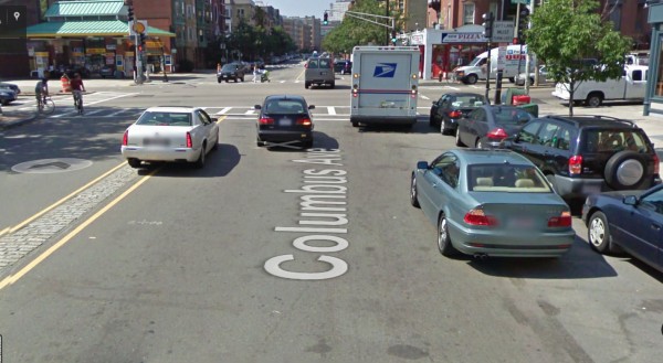
Here for comparison is a Street View from August, 2009. There is no shared-lane marking yet — those were installed sometime in the late summer or automn of 2011 — and if there are traffic signal actuator loops, they have been paved over. Cars are parked illegally up to the corner, and there’s a Post Office truck in right-hook position but apparently stopped to pick up or deliver mail: it has its warning blinkers on. The black car to its left is displaying a right-turn signal and the white Cadillac has merged over onto the median to continue straight through or turn left. A bicyclist looking to continue safely through the intersection would choose a line of travel behind the black car. And, yes a woman with a baby stroller is crossing against the light at the far side of the intersection, and at the left side, one bicyclist is making an illegal right turn on red while another is waiting in right-hook position. This is Boston!
You may click on the image to enlarge it, and also here’s a link, in case you want to take a look around starting at this point of view.
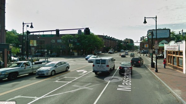
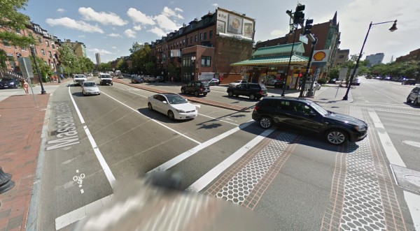
We go another 90 degrees clockwise: bike lane with “wait here” marking to the right of a lane with heavy right-turning traffic, but no actuator loop. This bike lane transitions from a door-zone bike lane in the background, behind the white truck. The left-turn lane has an actuator loop and a “wait here” marking not centered over the loop.
Here, again, is a link to the same view in Google, so you can look around and see earlier versions. I won’t clutter this post with more of them.
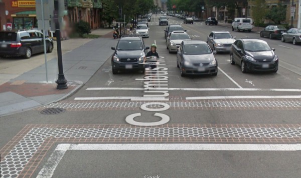
Another 90 degrees clockwise and the last of the four corners of the intersection: this time the actuator loop in the right lane is centered in the lane but the “wait here” marking is at the right side of the lane. A bicyclist riding at the right edge can also get right-hooked before the intersection by a vehicle pulling into the gas station on the corner. The bicyclist in this photo knows better than to wait at the right side of the lane.
There is an actuator loop in the left-turn lane, and a marking which is not over that actuator loop. A typical Boston door-zone bike lane is visible in the background.
Again, here’s a link to the Google Street View so you can look around and run the Google time machine backwards.
All four corners have signs, “to request green, wait on (bicycle symbol)” and No Turn on Red signs.
Now, let’s try to draw some conclusions.
Did the design of the intersection contribute to the crash? That is, did it play a part in inducing the bicyclist to ride into the “coffin corner”?
He’ll have to answer that, and maybe he will, because he survived, and his injuries were to the lower part of his body, not head injuries.
It is fair in any case to say that the placement of bicycle facilities in locations where bicyclists are out of sight and defenseless against ordinary traffic movements does cultivate unsafe behavior, in two ways:
- by leading bicyclists into the hazardous situations,
- and by creating the impression that the government knows what it is doing, and this unhappy compromise is the best one possible. Creating the impression that there’s nothing bicyclists could do for themselves to improve their safety traps them in a pattern of dysfunctional behavior.
The installations at this intersection are, however, not only misconceived. “Wait here” markings which are not over actuator loops reflect either pure incompetence or malice. A through lane without a receiving lane, and replacing correctly-located shared-lane markings with coffin-corner markings reflect — what?
Misconceptions and incompetence are the kinder explanation for all of these problems. A less kind explanation would be that the City is intentionally creating hazardous situations and tallying up bicyclist fatalities and injuries to make a case for the next bicycle facilities trend: “cycle tracks”, which place bicyclists behind barriers. I’d have to be paranoid to advance that explanation, though in fact if not in intention, that the current trend.
I can add that if Boston applies the same level of competence to cycle track siting and design as the City of Cambridge already has applied, we can expect worse problems. And, in fact, designs now on paper point the way to that outcome.

Pingback: Window dressing | Street Smarts
Damning indictment of the city, John.
Perhaps I am mistaken, but I thought the bicyclist and the truck were traveling southbound on Mass Ave and the truck was turning right (westbound) onto Columbus Ave. If that’s the case, that’s a pretty standard bike lane treatment. It’s even dashed to encourage motorists to merge over it before turning.
I don’t know exactly what happened in this case (who arrived first, whether the truck signaled, etc) but it’s a common scenario that happens whether or not there is a bike lane present. Bicyclists always need to watch out for right-turning traffic, and motorists always need to watch out for bicyclists to their right.
Charlie, you’re right about the direction from which the truck was coming. The buildings on the north and east corners look very similar but now I’m noticing a light-colored patch on the building in the background in both the Globe photo and the Street View. I’ll correct the article accordingly. As to “watching for right turning traffic”, my point is to stay out of the coffin corner and that means riding in the center of the travel lane where the driver who has to watch out for you can see you — whether or not there’s a bike lane trying to lure you into said coffin corner. Also note that the City has placed a “wait here” marking in the coffin corner, despite the absence of an actuator loop there. That is incompetent design, and/or incompetent contractor work, and lack of review of work.
I’ve noticed that too, on Mass Ave and in general, that the city and the state (and their contractors) have been very lazy about (a) painting the small bike stencils in the first place, (b) actually placing them in the correct spot over an actuator loop and (c) making sure the loop sensitivity is high enough to detect a bicycle. I’ve had a lot of trouble turning left onto St Boltolph St from Mass Ave southbound since the left turn lane actuator doesn’t detect me, and also getting a green light coming from St Boltolph St westbound since it doesn’t detect me there either. (I would argue that in an urban environment, having actuation is unnecessary in the first place, but that’s another issue altogether.)
There are many issues with this whole Mass Ave reconstruction that took place through the South End, most of which the city knew full well about before starting construction, but they opted to just move ahead without fixing them as they tend to do. (For example, note how the crosswalks not only do not line up with the pedestrian desire line, but actually put pedestrians on a crash course with the path of bicyclists because of how offset they are.)
Pingback: Separate but equal | Street Smarts
Some news stories about this incident:
Boston Magazine
Boston Globe
Boston Herald
Personal Injury Lawyer blog
Reddit — many comments from cyclists.